
Road blocks, Check points and Watch towers
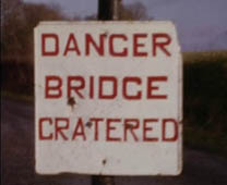
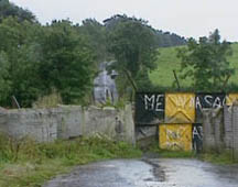
The Irish border has had its greatest physical presence in the landscape in the form of the structures set in place to regulate and monitor movement across it. The practice of making roads impassable through various forms of roadblocks began in the first decades following Partition when attempts were made to prevent people avoiding custom points by using unapproved roads nearby. However, it was in the 1970s and 1980s that the blocked roads came to be such iconic images of the border and a dominant feature of borderlands life. From the 1970s roads were blocked by the security forces in attempts to prevent paramilitary movement across the border and to make the border impermeable except for the crossing points subject to security checks. Roads were blocked with reinforced concrete blocks, metal spikes and craters; bridges were destroyed to make border-crossings via minor roads impossible. In some areas these roadblocks were regularly challenged by locals who removed concrete blocks or filled in trenches and were regularly reinstated by security forces.
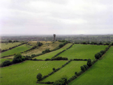
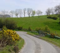
While over one hundred unapproved roads were blocked during the Troubles, the approved roads crossing the border featured the infrastructure of military checkpoints – soldiers, armoured vehicles and fortified buildings. Security measures also included covert military surveillance of border landscapes through the string of watchtowers that were erected on the hills of the border counties in Northern Ireland, especially in south Co. Armagh and south Co. Tyrone. These watchtowers dominated the skylines of the most heavily militarized districts of the borderlands. The army checkpoints that dominated the borderlands during the Troubles no longer exist. Following the paramilitary ceasefires of 1994 security measures were considerably reduced and formerly blocked border roads began to be re-opened. Watchtowers are now being dismantled in the post-conflict demilitarization of Northern Ireland. Travelling through the borderlands today, it is very difficult to find evidence of the roadblocks and checkpoints that once existed. They feature strongly in the stories of borderland lives but are largely now invisible in the landscape. Only the obviously new bridges that can be found along small country roads crossing the border suggest that they replace a bridge destroyed by the security forces.